Corrinne Burns blogs on ADIOS, a GPS enabled javelin which helps tracks icebergs. You can see ADIOS on display in the Museum’s contemporary science gallery.
Why would you put a GPS tracker onto a glacier? These positioning devices are more commonly associated with cars. It’s not like glaciers are in any danger of getting lost – or of ending up in a field of bemused cows, for that matter.
Actually, there’s good reason why scientists track the movement of ice. The Antarctic Ice Sheet is the biggest unknown when it comes to predicting sea level change.
Glaciers move – we all know that. It’s natural. But as the ocean temperature rises, glaciers move at an increased rate. That’s because melting, triggered by the warming sea, causes the ice streams within the glacier to flow faster and faster.
And of course, as glaciers melt, the global sea level rises.
So this “flow velocity”, as glaciologists call is, can be used as a way to track rising sea levels. That’s why it’s so important to track the movement of glacial ice streams.
Hilmar Gudmundsson works at the British Antarctic Survey, keeping an eye on ice dynamics. He’s been putting GPS trackers onto glaciers for a while now. Traditionally, a helicopter lands a crew onto the glacial surface, and then they walk across the frostbitten landscape, implanting trackers as they go.
But Hilmar knows how dangerous walking on ice can be – deep crevasses await the unwary. So he helped to invent a rather unusual way to deploy such trackers, so that no human need even set foot on the ice.
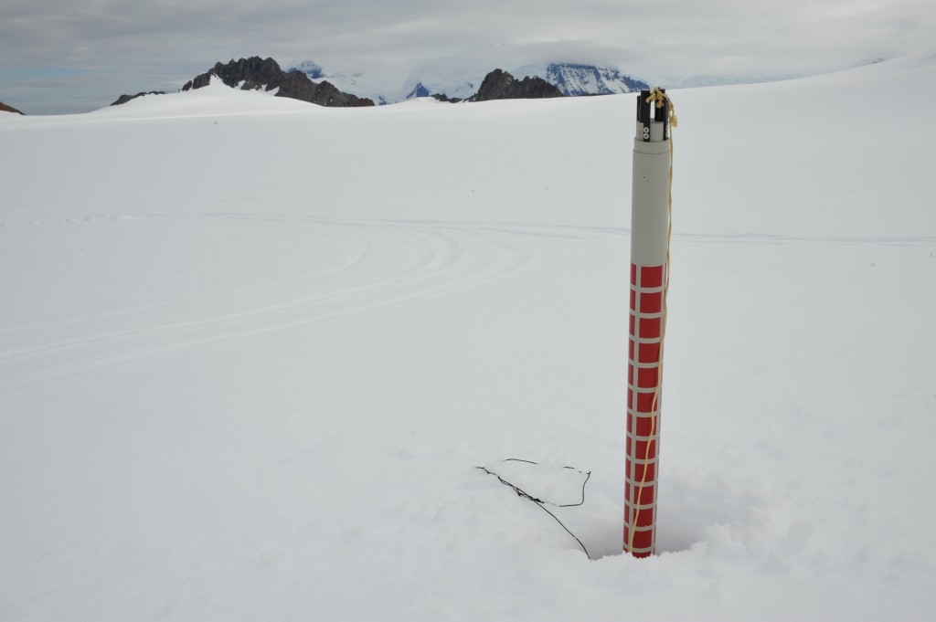
The solution was ADIOS – the Aircraft-Deployable Ice Observation System. ADIOS is, essentially, a GPS tracker embedded within a 2.5-metre long javelin, designed to be dropped from an aircraft flying a few hundred metres above the ice. One such ADIOS device is currently on display in the Museum’s Antenna gallery.
ADIOS takes inspiration from technology originating from World War Two – the sonobuoy. These were floating sonar transducers, deployed by aircraft into the ocean to listen out for warships. Hilmar and colleagues adapted this wartime concept for the 21st century Antarctic – but glaciers do present some challenges that water does not.
For one, the electronics needed to survive the impact on hard ice – a polyethylene cushion and a spring help to protect them from impact forces of up to 1200G, and a parachute slows and stabilises ADIOS’ descent. You also need to consider the effects of snowfall – anything placed on the surface is likely to be covered in snowdrifts pretty quickly.
Those considerations led to the long, aerodynamic javelin-like design.
The GPS tracker itself is positioned towards the sharp nosecone-end of ADIOS, and, after landing, sits below the surface of the ice. It transmits through an antenna situated at the opposite end of the javelin – which, thanks to four “snow brakes”, remains above the snow surface. It is so long that it can remain uncovered even following thick snowfall, transmitting for up to two years.
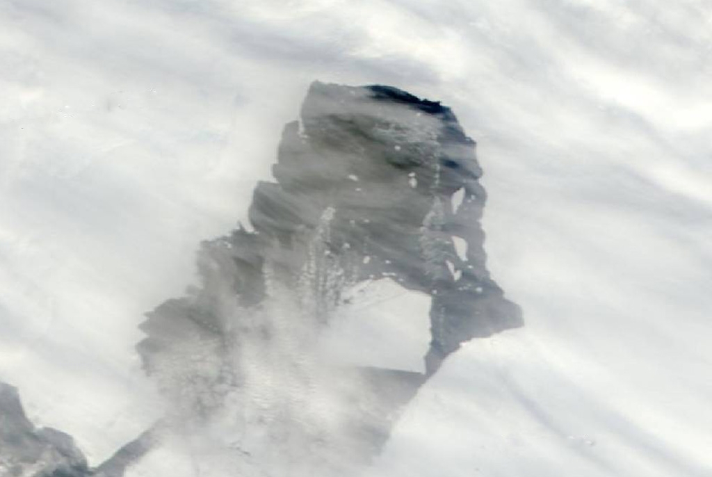
Hilmar’s interested in part of Antarctica called the Pine Island Glacier, or PIG. His team deployed 37 ADIOS sensors onto the glacier in January of last year. PIG is significant because of all the icy regions on Earth, this glacier is showing the biggest changes in ice movement and thickness, so we need to keep an eye on it. “We can already see that the rate of ice flow is increasing, since we deployed those units,” says Hilmar.
Even more dramatically, a few months ago a 700 square km bit of PIG broke off, forming a massive rogue iceberg that is now further fragmenting and drifting towards shipping lanes. Two ADIOS’ sit on that rogue berg – not by coincidence. “We knew that this ice was breaking away from PIG – that’s why we put two ADIOS units on it,” says Hilmar. As the rogue iceberg has broken apart further, those units now sit on two different fragments – and are still sending back live data about position.
So, as well as telling us about glacial melt, ADIOS units can be used to track the movements of icebergs heading for shipping lanes. Will we see more air-deployed GPS trackers on icebergs around the world, then? “This is now tried-and-tested technology. There’s a lot of interested from other researchers, and we’ll let them use the design,” says Hilmar. “And for me – I’m relieved that it works!”
You can find out more about ADIOS, in the Science Museum’s contemporary science gallery from now until April 10, 2014.