One hundred years ago in the summer of 1917, Allied troops launched the Passchendaele offensive against the German Empire. While the offensive would ultimately fail some of the medical developments used to save the lives of those involved continue to be used in war zones today.
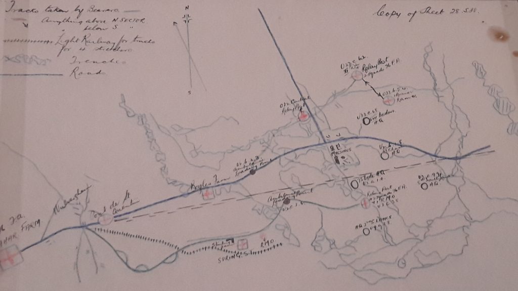
A simple blue crayon line on a map marks the road from the medical HQ of the 76th Field Ambulance all the way to Messines Ridge. The high ground of the ridge was the target of a major Allied operation as a preliminary to the Passchendaele offensive. You can see the map on display in Wounded, currently in the Mezzanine gallery at the Science Museum, and as you follow the blue line, you can see how it is intersected more densely as the front approaches. There is the trench network itself, a small gauge railway line leading to a casualty clearing station, and newly dug straighter tracks (marked in green) so that stretchers laden with their casualties could be carried easily and quickly away from the battlefield without having to turn too many corners.
The attack on Messines Ridge marked a new phase in the Great War. In addition to the weeks of bombardment before 7 June, nine divisions of men were ready to be hurled at the enemy, nineteen deep gallery tunnels had been dug under the ridge leading to mine chambers packed with a million pounds of explosives. They were detonated just before dawn, in the largest man-made explosion to that date on our planet, its sound carrying from Ypres to London on the wind.
When the dust settled, the ridge had almost disappeared. Allied forces moved forward to occupy the once-dominant German positions and scored one of the few unequivocal victories of the war. But from then on, through the summer and into the late autumn, the offensives slowed, bogged down in dreadful weather and appalling mud. Eventually there would be utter failure and no meaningful gains, in the end 70,000 British soldiers were killed and another 170,000 wounded.
The map in the Wounded exhibition was drawn by a Regimental Medical Officer (RMO) in preparation for the attack on Messines Ridge, and would have been one of a number distributed to his stretcher bearer team leaders. This one is in perfect condition, the colours from the crayons used to mark the routes from the front to the rear are clearly distinguishable a century after its creation, so it must have been kept as a copy, in a personal or Field Ambulance record. At first glance, the map appears to be a tangle of lines but look more closely and we see careful preparation by a medical service well-used to attritional warfare: many medical relay posts set up and stocked with their supplies of dressings and morphia, multiple options for bearers running back with their patient on their stretcher, then going out again, picking up what they needed, or finding another relay post if where one had been destroyed or the pathways to it wrecked. It’s a very precise document because men’s lives literally depended on the RMO’s cartographical skills and his bearers’ ability to interpret them.

Opposite the map in its case is an entirely different object but one every bit as important to the medical effort for the Passchendaele casualties: Oswald Hope Robertson’s blood transfusion kit in its portable wooden case. The techniques of blood transfusions were still in development during the war and Robertson had been one of the very first to perform them in 1915. He had worked all over the Western Front installing transfusion and blood storage facilities, and training medics in their use.
His work at Passchendaele in its dying days was recorded in his diary the horror that he understood only too well:
“Haemorrhage, haemorrhage, haemorrhage – blood everywhere – clothes soaked in blood, pools of blood in the stretchers, streams of blood dropping from the stretchers to the floor. I was in blood up to my elbows and my rubber apron was one solid red smear. All we could do was to stop the bleeding and get the patients as comfortable as possible.”
Robertson and his colleagues picked up their patients where the stretcher bearers delivered them as instructed by their medical maps. In one 24 hour period, the field hospital where he worked admitted 1800 patients, there were simply too many for him to do transfusions for all of them, but he did his best to control their bleeding however he could.
At Passchendaele, both medics and bearers must have felt as if no matter what they did, the deluge of the wounded and dying wound never stop. But they all worked on, and in doing so, transformed the prospects of military casualties then and ever since.
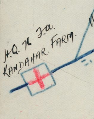
There is a final detail on the map – almost unnoticeable unless you are looking for it – the name of the headquarters of the field ambulance: Kandahar Farm. The post was named for a previous posting by a battalion reassigned to Passchendaele: Kandahar in Afghanistan. There are still British troops in Kandahar, part of the much smaller force left behind after the end of Operation HERRICK in 2014. During that conflict, medics learned again about blood, and its horrors. You can see the equipment they used in a case at the very end of the exhibition – the end of a road begun on a small map, drawn in coloured crayon, by medics determined to save lives, and keep them saved, no matter what the journey.
Dr Emily Mayhew is a military medical historian. She has written two books: “Wounded: the Long Journey Home from the Great War” and “A Heavy Reckoning: War, Medicine and Survival in Afghanistan and Beyond.” Both are available from the Science Museum shop.
Our sister museum, the National Railway Museum in York, has also been exploring medical care in the First World War in their exhibition Ambulance Trains, showing until the end of 2017
3 comments on “Wounded: maps, blood transfusion and the Passchendaele centenary”
Comments are closed.
I wonder if my Grandad had this map?? He was at Passchendaele and the Somme.I only have one page from his trench diary and it is not nice reading.He lived to tell but so many did not.He was with the 5th Black Watch and very proud of it.May they all R.I.P.
I should have said he was there as a stretcher bearer to he would of been using the directions anyway.
Impressive observation, appreciate your posting it
I must say I have gained a lot of awareness from this document, continue the good work, thank you
so much. https://www.boisedentiste.com/05/2016/crest-teeth-whitening-strips-really-work/